What Is GPS and How Location Tracking Really Works
Discover how GPS revolutionized navigation. Understand how satellites work and how this technology is embedded in your daily life.
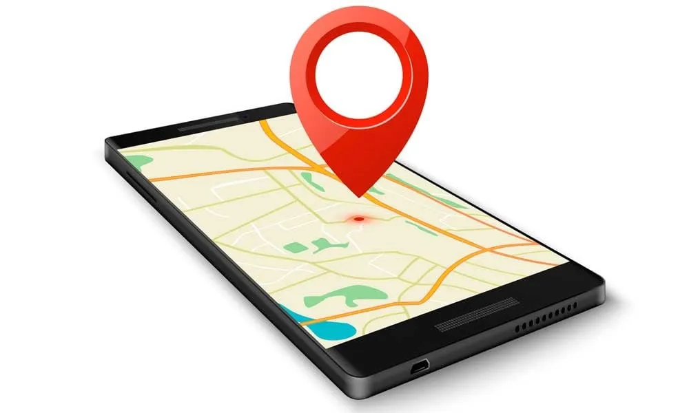
Have you ever wondered how your smartphone can pinpoint your location within just a few yards anywhere on the planet? How rideshare apps find you in a crowded street and how navigation systems know exactly which route to take?
The answer is literally floating above our heads: a network of 24 satellites orbiting our planet at over 12,400 miles altitude. GPS has become one of the most revolutionary technologies, completely transforming our relationship with navigation.
In this guide, I'll explain how this incredible technology works - technology that's embedded in virtually every aspect of our modern lives. You'll discover everything from basic concepts to advanced GPS applications.
Table of Contents
- What Is GPS
- How GPS Works
- GPS System Components
- Types of Positioning Systems
- GPS Accuracy and Limitations
- GPS Applications in Daily Life
- GPS vs Other Systems
- The Future of Location Technology
- Frequently Asked Questions
- Conclusion
What Is GPS: Definition and Basic Concepts
GPS stands for Global Positioning System, a technology developed by the United States in the 1970s, initially for military use. Today, this tool has become indispensable for billions of people worldwide.
GPS is essentially a satellite navigation system that allows you to determine the exact location of any point on Earth through geographic coordinates. Besides position, the system also provides precise information about altitude, speed, and timing.
The technology works 24/7, in any weather condition, and is available free of charge for civilian use. GPS doesn't need internet to work - it communicates directly with satellites through radio signals.
Understanding how GPS integrates with modern devices becomes fascinating when you consider how it works alongside other technologies. For instance, check out our guide on RAM and device performance.
How GPS Works: The Science Behind Location Tracking
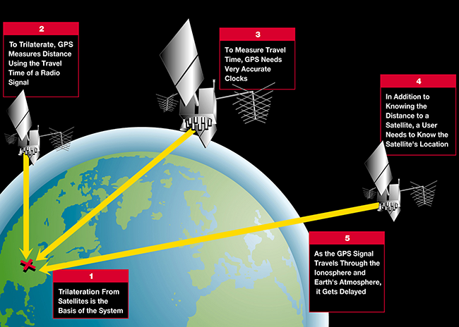
GPS functionality is based on well-established mathematical and physical principles. The core concept is trilateration - a process that uses distance from multiple references to determine exact location.
Each GPS satellite orbits Earth approximately twice daily at an altitude of about 12,550 miles. They continuously transmit radio signals containing their exact position and the precise time the signal was sent.
When your GPS device receives these signals, it calculates the time each signal took to reach you. Since signals travel at the speed of light, it's possible to calculate the distance to each satellite by multiplying speed by travel time.
The Trilateration Process
If you know your distance to three satellites, you can determine your position in three-dimensional space. It's like being at the center of three imaginary spheres - you're located exactly where these spheres intersect.
For greater accuracy, especially to determine altitude, a fourth satellite is necessary. This allows the system to correct small synchronization errors between satellite clocks and your receiver device.
Each GPS satellite is equipped with extremely precise atomic clocks. A difference of just one millionth of a second can result in a location error of 984 feet!
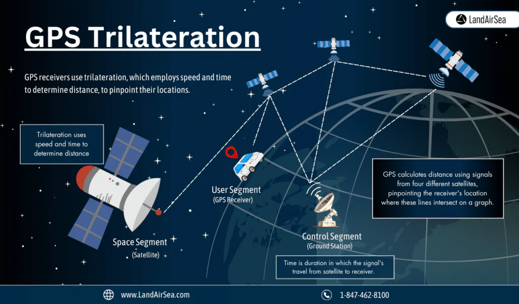
GPS System Components
The GPS system consists of three main segments that work together to provide precise location information.
Space Segment
The "heart" of GPS, composed of 24 active satellites plus several backups. These satellites are distributed across six orbital planes, ensuring at least four satellites are always visible from any point on Earth.
The satellites are built to last 10-15 years and are regularly replaced with more modern versions. They have solar panels for power and atomic clocks to maintain temporal precision.
Control Segment
Located primarily in the United States, this segment is responsible for monitoring and maintaining the entire satellite constellation. It includes monitoring stations around the world that constantly track the satellites.
Control stations verify satellite orbits, update navigation data, and make corrections when necessary. It's like a "command center" ensuring the entire system operates with maximum efficiency.
User Segment
This segment is us! It includes all GPS receiver devices - from smartphones and tablets to automotive navigation systems and professional surveying equipment.
GPS receivers vary enormously in complexity and accuracy. A typical smartphone has accuracy of about 10-16 feet, while professional equipment can achieve centimeter-level precision.
Types of Global Positioning Systems
While American GPS is the most well-known, there are other satellite navigation systems developed by different countries and regions.
GPS (United States)
The original and most popular system, with 24 operational satellites and complete global coverage. It offers accuracy of approximately 10-16 feet for civilian use.
GLONASS (Russia)
Developed by the former Soviet Union and modernized by Russia, GLONASS has 24 active satellites. Many modern devices combine GPS and GLONASS signals for better accuracy.
Galileo (European Union)
The European satellite navigation system, designed specifically for civilian use. It offers higher accuracy than traditional GPS and operates completely independently.
BeiDou (China)
The Chinese system that became fully operational in 2020. It offers global coverage and is being rapidly integrated into Chinese electronic devices.
NavIC (India)
India's regional system that provides coverage primarily in India and neighboring regions, with superior accuracy in its coverage area.
Most modern smartphones can use signals from multiple systems simultaneously, resulting in faster and more accurate location fixes. This is especially useful in dense urban areas.
GPS Accuracy and Limitations
GPS accuracy varies significantly depending on various environmental and technological factors. Under ideal conditions, typical accuracy is 10-16 feet for consumer devices.
Factors Affecting Accuracy
Physical obstacles are one of the main limitations. Tall buildings, mountains, dense trees, and thick clouds can block or reflect GPS signals, causing inaccuracies or signal loss.
Atmospheric conditions also impact performance. The ionosphere and troposphere can delay GPS signals, resulting in small calculation errors. Solar storms can cause more significant temporary interference.
Clock errors between satellites and receivers, even minimized by atomic clocks, can still cause small inaccuracies. This is why at least four satellites are needed for proper triangulation.
Enhancement Technologies
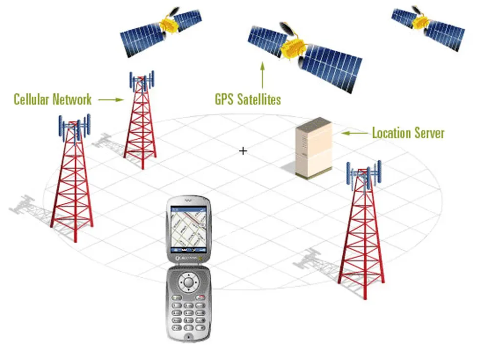
A-GPS (Assisted GPS) uses cell towers to speed up signal acquisition and improve accuracy, especially in dense urban environments.
DGPS (Differential GPS) uses terrestrial reference stations for real-time corrections, achieving accuracy of a few feet or even centimeter-level in professional applications.
RTK (Real Time Kinematic) offers centimeter-level accuracy for specialized applications like precision agriculture and topographic surveys.
GPS Applications in Daily Life
GPS has integrated so completely into our daily lives that we often don't even notice its presence. The technology has revolutionized various sectors.
Navigation and Transportation
Map apps like Google Maps, Waze, and Apple Maps have completely transformed how we navigate. They not only show our location but calculate optimized routes and avoid traffic.
Rideshare apps like Uber depend entirely on GPS to connect passengers and drivers, calculate distance-based fares, and optimize routes.
Public transportation also benefits enormously. Monitoring systems use GPS to provide users with accurate arrival time information.
Delivery and E-commerce
Delivery apps have revolutionized how we order food and products. GPS enables real-time delivery tracking, delivery time calculations, and route optimization.
E-commerce and logistics depend on GPS for package tracking, delivery route optimization, and efficient fleet management.
Fitness and Health
Fitness devices like smartwatches and fitness trackers use GPS to track runs, walks, and cycling, calculating distance covered, speed, and calorie burn.
Running apps like Strava create entire communities based on GPS data, enabling virtual competitions and route sharing.
Safety and Emergency Services
Emergency location allows emergency services to find people in critical situations. Many countries automatically send GPS location when you call emergency numbers.
Vehicle tracking is used for stolen vehicle recovery and commercial fleet monitoring, significantly increasing security.
GPS vs Other Navigation Systems
It's interesting to compare GPS with other location technologies to understand when each is most appropriate.
GPS vs Wi-Fi Positioning
Wi-Fi positioning uses signals from known Wi-Fi networks to determine location, especially useful in indoor environments where GPS doesn't work well. It's less accurate (33-164 feet) but works inside buildings.
GPS vs Bluetooth Beacons
Bluetooth beacons offer high-precision location (up to 3 feet) in small indoor spaces, like stores and museums. They're ideal for indoor navigation and personalized experiences.
GPS vs Cell Tower Triangulation
Cell tower triangulation uses cell phone towers to estimate location. It's less accurate (328-3,280 feet) but works when GPS isn't available and consumes less battery.
GPS vs GNSS
GNSS (Global Navigation Satellite System) refers to the combined use of multiple satellite systems. It offers higher accuracy, faster signal acquisition, and better performance in challenging environments.
The Future of Location Technology
Global positioning technology is in constant evolution, with significant improvements being implemented regularly.
Modernization of Existing Systems
GPS III represents the new generation of American satellites, offering signals three times more accurate, eight times better interference resistance, and improved performance in dense urban environments.
Galileo High Accuracy Service promises accuracy of 8 inches or better for commercial applications, revolutionizing sectors like agriculture and construction.
Emerging Technologies
5G positioning is being developed to offer precise location in indoor environments using fifth-generation mobile network infrastructure.
Quantum positioning represents a futuristic technology that could offer extremely precise location even where satellite signals don't reach.
Integration with Other Technologies
Artificial Intelligence is being integrated into location systems for movement prediction, intelligent route optimization, and personalization of location-based experiences.
Internet of Things (IoT) is expanding GPS applications to billions of connected devices, from home appliances to smart urban infrastructure. Learn more in our article on IoT and smart homes.
Revolutionary Applications
Autonomous vehicles depend on ultra-precise positioning systems combined with other sensors for safe navigation.
Augmented reality uses precise location to overlay digital information on the real world in contextually relevant ways.
Smart cities use aggregated location data for traffic optimization, urban planning, and more efficient public services.
Frequently Asked Questions
What is GPS and how does it work?
GPS (Global Positioning System) uses 24 satellites orbiting Earth at 12,550 miles altitude to determine your exact location through radio signals and trilateration calculations that measure signal travel time.
Does GPS need internet to work?
No, GPS communicates directly with satellites through radio signals and doesn't require internet connection to determine your location. However, maps and navigation apps need internet for map data.
How accurate is GPS?
Consumer GPS devices typically have accuracy of 10-16 feet under ideal conditions with clear sky view. Professional equipment using enhancement technologies like RTK can achieve centimeter-level precision.
What affects GPS accuracy?
Physical obstacles like buildings and mountains, atmospheric conditions, clock synchronization errors, and the number of visible satellites all affect GPS accuracy. Indoor environments also significantly reduce GPS performance.
What's the difference between GPS and GNSS?
GPS is specifically the American satellite system, while GNSS (Global Navigation Satellite System) combines multiple satellite systems (GPS, GLONASS, Galileo, BeiDou) for better accuracy and reliability.
Can GPS work indoors?
GPS signals struggle to penetrate buildings, making indoor location tracking unreliable. Instead, indoor positioning uses Wi-Fi, Bluetooth beacons, or cell tower triangulation for location services.
How many satellites do you need for GPS to work?
You need signals from at least 4 satellites for accurate 3D positioning. Three satellites determine your position, while the fourth corrects timing errors and determines altitude.
Conclusion
GPS represents one of humanity's most impressive technological achievements. What started as an American military project has transformed into fundamental technology that connects billions of people around the world.
Understanding how GPS works helps us appreciate the technological complexity that operates silently in our daily devices. From checking traffic on our smartphone to ordering delivery, we're constantly interacting with this network of satellites orbiting our planet. The continuous evolution of location technology promises even more revolutionary applications in the future - autonomous vehicles, smart cities, and augmented reality are just the beginning of a new era where precise location will be even more central to our lives.

